


Another Trip to Oregon, Part XV
Day 36: The Aufderheide Scenic Drive

There’s a 60-mile paved Forest Service road that goes through the mountains and forest from the Middle Fork of the Willamette River to the McKenzie River. It is one of the most scenic drives you can take in a car, and there is no civilization anywhere along it.
Named after Bob Aufderheide, a former Forest Service boss of the Willamette National Forest, it is one of the most scenic drives in Oregon, and after the first three miles or so it is completely wild: no civilization. So if you’re going to do it, fill up your gas tank in either Oakridge or Blue River, depending on which way you’re going. Also make sure you have drinking water and picnic food.
This road was part of my “paved route through the Oregon Cascades” that I was traveling. Here’s a screenshot from Google Maps showing this portion of it, in case you want to go there yourself:

In the direction I was going, the road begins literally across the highway from the Oakridge Forest Service ranger station, a beautiful building that is worth a stop if they are open when you are there. Among the attractions there is a giant tabletop 3-D model of the ranger district with its mountains, valleys, lakes, etc. that is stunning to behold. They of course also have full information on all of the campgrounds that you’ll be passing if you’re inclined to camp along your way.
It’s a two-lane paved road, but not a highway. Not bumpy, but you won’t be going very fast.
The first attraction along that road is a historic covered bridge at the town of Westfir. It’s worth a stop to look at the construction technique they used back in the olden days to build them. Yes, you can walk across the bridge but it’s closed to vehicle traffic.
I mentioned it briefly in this Substack from a couple of years ago:
My Last Backpacking Trip

I hope to get my ducks in a row to start backpacking again this year. But for now, this is the last one I did. My son had engaged a lovely bride-to-be while overseas, and wanted to show her what backpacking in Oregon is like. I was living in Tennessee. “OK,” I said. “I’ll fly out to Oregon.” I bought a GPS unit for my camera. I wanted pinpoint loca…
The road follows the North Fork of the Middle Fork of the Willamette River - through dense forest - past campgrounds, fishing holes, trailheads into the Wilderness, and other magical places. Several miles up is a spot I don’t have photos of (I think I have some old film shots, but they aren’t scanned) called “Constitution Grove.” It’s worth stopping and taking the little loop trail through. Those are trees that were alive when the US Constitution was written 250 years ago. They are giants.
Farther along, the road climbs up the end of a box canyon to the road’s summit between the two river drainages. At that spot is a large, beautiful meadow with a historic ranger station, and a historic cabin that once housed firefighters:
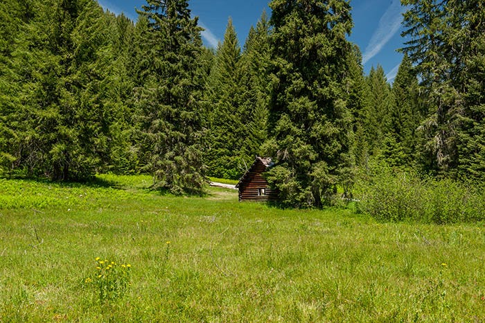
Paid subscribers received a full-resolution, suitable for printing and framing, copy of this image a few weeks ago.
Can you imagine having been stationed there for the summer in the 1930s? You would never want to go back to civilization. With all of that lush grass to eat, your horse would be the happiest animal in the world!
From this point, the road skirts the Three Sisters Wilderness, past several trailheads leading into it.
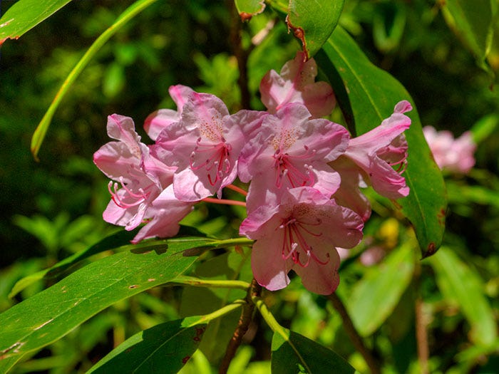
Another thing of beauty for which this road is famous is the rhododendrons. They bloom in June.
Proceeding north from here, the road descends down the South Fork of the McKenzie past more campgrounds, more Wilderness trailheads etc. to Cougar Reservoir. There is a hot springs there that is very popular with the Eugene hippie crowd, complete with naked hippies pretty much any day (sorry, I have no photos of the naked hippies for you). Parking is very limited there, and my motorhome + Jeep is fifty feet long, so I didn’t stop on this particular trip.
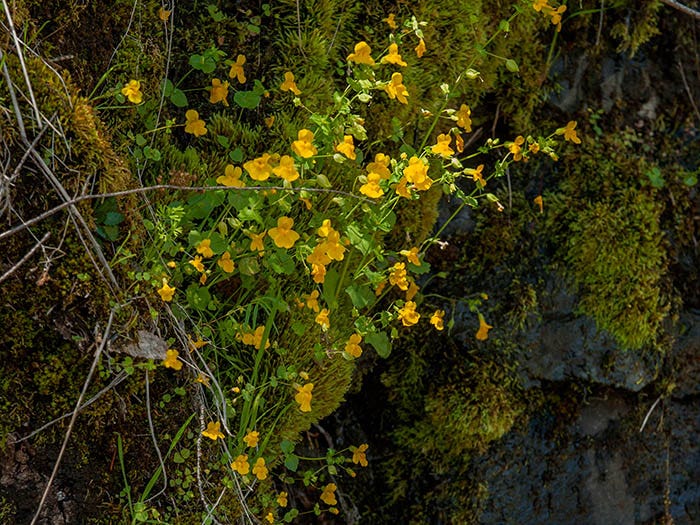
But there is a spot just past there, basically at Cougar Dam itself, with room to pull over — and some dripping cliffs adorned with yellow monkeyflowers.
I apologize for shortchanging you, the viewer, on this post with so few pictures. I do need to go back along this road in my Jeep, where I can pull off the road anywhere I want, and do more photography. But for now, this is all I have.
After reaching the McKenzie, I spent a few days at the Trail Bridge campground where I have some fond memories - mostly of Pookie acting like a much bigger cat - but regrettably no photos. I don’t remember why; perhaps my Muse had to leave me for a bit to go inspire some other photog. I do remember that there were several days of rain and I don’t generally try to do scenic photos in the rain.
So, this post has fewer photos than usual but I’ll make up for it by making my next post a little sooner than usual.
Oh, now I see it! Thanks for clarifying that. I drove SR242 a couple times long ago, but I don't think I ever wandered Aufderdeide. Maybe someday....
Oh! I think that's the route I grew up hearing called "The Old McKenzie Highway." If we're talking about the same thing, I second it: it's an incredible trip! Slow, but very worth the time.