

The Colorado National Monument
The Colorado National Monument
Number 3 on my list as a new Grand Junction resident

If Grand Junction has a jewel, it’s the Colorado National Monument. I had been there before:

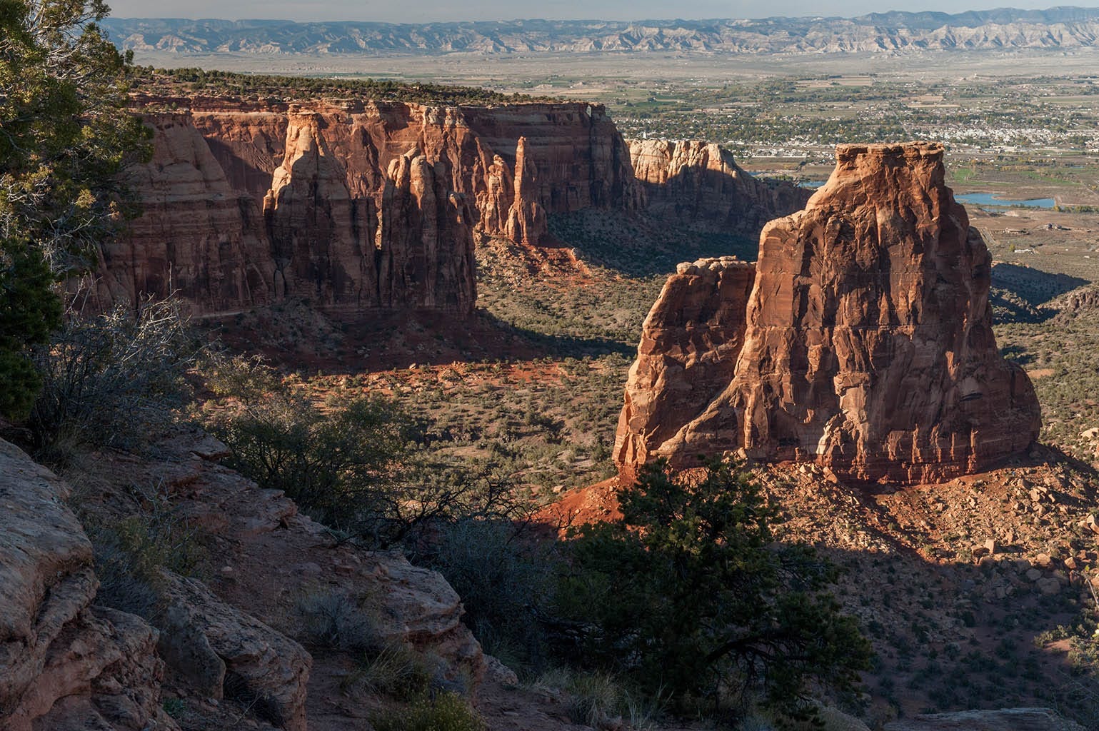
Now, years later, I finally lived next to it. So, after photographing Mt. Garfield up close and personal (1st item on my list), and visiting the Grand Mesa (2nd item on my list), I set my sights on “the Monument” right next to town. It was third because I’d already been there, but wanted to spend more time and see more of it. It’s a roughly triangular area about ten miles across on the long side, containing spectacular eroded cliffs and pillars, spires, etc. in the hollowed-out areas.
There are two entrances: one on each end of the triangle. From each end, a road goes to the top of the cliffs, along them past various viewpoints, and back out the other end. That road is about 22 miles from one gate to the other. Here are shots from two trips up there, done about a day apart.
The East gate
The long side of the Monument runs northwest to southeast. The gate on the southeast end is called the “East” gate by the National Park Service. That was the closest one to me. I went up that end first.
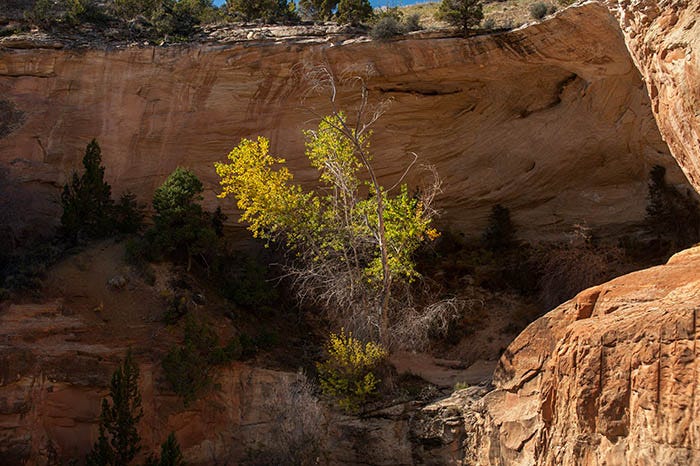
On the way up, there is this lovely cottonwood tree eking out an existence in the rocks. Very photo worthy.
The first viewpoint after getting on top of the mesa is called Cold Shivers:

Yeah, it gives me the shivers all right. In all the years I lived in and around Grand Junction, I never stepped on the top of that rock. It just gave me “the willies.” I couldn’t get past the question “what if it tips over while I’m on it?” in my mind.
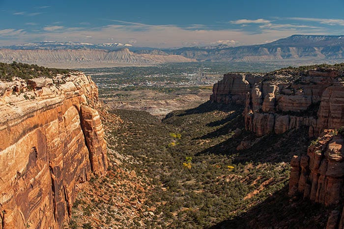
That’s the city of Grand Junction, about 500 feet below, and the Book Cliffs, explained here, on the other side of the Grand Valley.
We are standing here on a tableland (mesa) that was uplifted in the Laramide Orogeny (the same event that created the Rocky Mountains, which begin 60-some miles to the east of here) 70 to 50 million years ago. Down at the bottom you can see a hill with reddish streaks going around it; that is the Morrison Formation, laid down 150 million years ago and containing most of North America’s dinosaur bones. We are standing on the Kayenta formation, which is around 50 - 80 million years older. Yes, the older rock is higher because this is an uplift. This spot once had Morrison Formation rock above it, but it all eroded away millions of years ago.
In and around Grand Junction, the Kayenta formation is only a few inches to about a foot thick, but it has about the same toughness as concrete. The Wingate formation, the red stuff directly beneath the Kayenta and hundreds of feet thick, is not so tough. Where ever erosion managed to wear through the Kayenta, the Wingate eroded away very quickly. That is the reason for these spectacular cliffs.
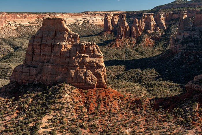
My last stop of the day was at the view of the next canyon over, Red Canyon.
Here’s a pretty good view of the whole area. All three items that were on my “list” - Mt. Garfield, the Grand Mesa, and the Colorado National Monument - are in this shot.
Notice that the bottom of this canyon is still well above the valley floor. It is composed of the Proterozoic “basement rock” that underlies virtually all of Colorado. It is black, 1.7 billion years old (see my post about the Black Canyon of the Gunnison, here) and very, very tough. It has hardly eroded at all.
A couple of days later, I went to the other end of the Monument and came this way on the road.
The West gate
This is right behind the town of Fruita, Colorado and is what you might call the main entrance because the Visitor’s Center is on this end of the Monument. Also the iconic views. The one campground in the Monument is right there1, as are the majority of the developed viewpoints. You climb up a serpentine road, through a tunnel and eventually come out on top of the mesa. Here is the iconic view down into Monument Canyon, the Monument’s largest, from near the Visitor’s Center:
John Otto, an eccentric who was primarily responsible for the creation of this National Monument and became its first park ranger, climbed up Independence Monument one Fourth of July and planted an American flag up there. It is now traditional for climbers to do that every year. This shot was made in October, so no flag, but there ARE climbers on this rock in this photo. Here are three of them:

Two are in the lower left; one in the upper right. Another popular spire for climbing is Sentinel Spire, also near the Visitor’s Center.

Yes, there is someone on top of that one too:
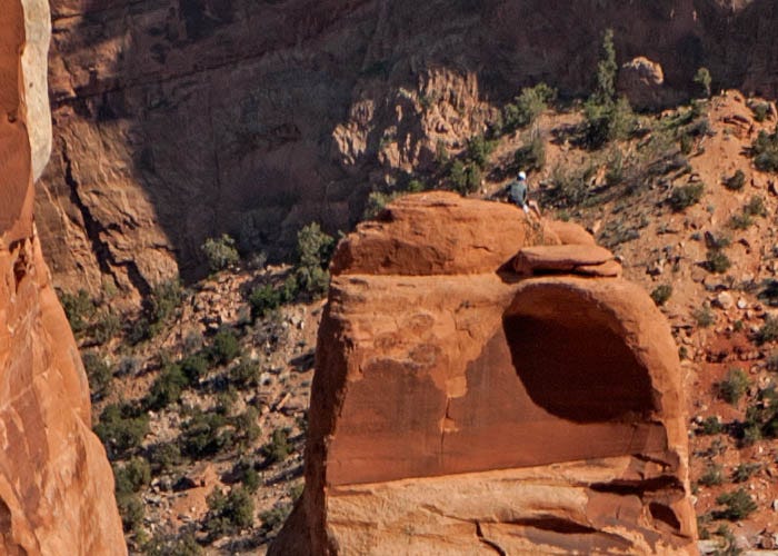
Not for me, man. That stuff gives me the willies just thinking about it.
There is one more geological formation worth mentioning here: the deep-red stuff at the bottom of this spire, and all of the spires and cliffs: the Chinle Formation. It is very, very crumbly rock that underlies the Wingate Formation. In this location, it lies on top of the 1.7 billion year old Proterozoic basement rock, but it is only about 200 million years old. So there is 1.5 billion years’ worth of rock missing here. Further west, in Utah, there are other formations under the Chinle, but in this spot, all of them eroded away before the Chinle was deposited.
This post is already long so I’ll leave you with one more shot, taken from the other side of Independence Monument, looking back toward the Visitor’s Center - which is in the shot, but too small to see in these reduced-size images that I post here. However, this one is bigger than the usual. You can zoom in a little bit by clicking on it.
There is a person in this photo, at the base of Independence Monument. If you zoom in to the photo, you’ll be able to just barely see him. He’s wearing blue.
Paid subscribers received a full-resolution, suitable for printing and framing, copy of this image about a month ago.
I made many, many trips up to the Monument during my years in Grand Junction. You will see many more stunning shots of it in future posts.
The campground will accommodate smaller RVs, but I can’t imagine anyone wanting to take an RV up that road!
Seeing the people in these shots (which I would not have noticed without your mention) gives an excellent perspective of the enormity of these formations. Quite spectacular!