


A Big Road Trip
Day 6: North Rim of the Black Canyon of the Gunnison

The south rim of the Black Canyon of the Gunnison National Park is the developed side. The road through it is paved, there is a visitor center, the campground is nice (it even has a few RV sites with electricity), and the viewpoints have fences and other barriers to keep you from falling into the canyon. It is easily accessible via a side road from US Hwy 50.
The north rim is raw, undeveloped and primitive. The best access to it is via Colorado’s “West Slope” (Grand Junction area); the road from the east is narrow, winding and very long. The last several miles of road to it are gravel, and a little rough. The campground is designated “primitive camping” - dirt / gravel, off the grid, pit toilets, and not really suitable for RVs. There is a water spigot there.
A few of the North Rim viewpoints have some kind of protective fence or stone wall to keep you from falling into the canyon if you slip. Many do not. It is a very different experience from the South Rim. Let’s call it “primal.”
But the views… Oh Em Gee.
My base camp was in the city of Gunnison. It’s a long way to the Black Canyon from there, but there is some interesting geology along the way. We’ll talk about that in this post.
The geological story around Gunnison, Colorado is a complex one. While most of Colorado’s story is relatively simple - layers being deposited on top of layers, some getting pushed up, others getting eroded away, etc. - the Gunnison area has a very different geological history, comprising the uplift that formed the Rockies (aka the Laramide Orogeny), volcanism to the north about ten million years later (the West Elk mountains) and then different volcanic activity to the south a few million years after that. So you have tuff on top of breccia on top of proterozoic basement rock. If you’re confused by all of this — well, so am I.
So you can see rocks that are radically different from each other within a few miles of each other, and sometimes in the same place. For instance, just a few miles out of town, you see this beside the road:
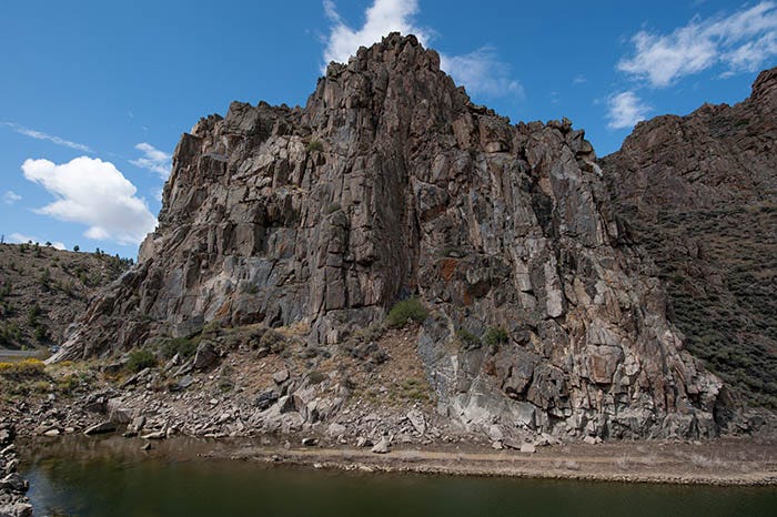
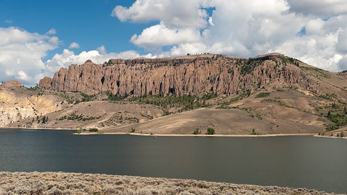
And in a few more miles, you see this:
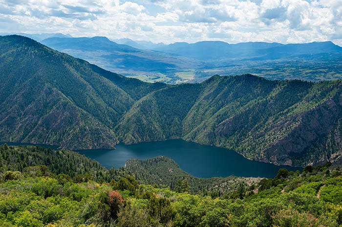
Twenty-five miles from town, I turned off US Hwy 50 onto State Route 92. The road crosses the river atop the dam to Blue Mesa reservoir and heads north into some remote country. Immediately below the Blue Mesa reservoir, Colorado’s largest1, begins the Morrow Point Reservoir. SR 92 affords some nice views down into this body of water to which there are no roads:
Off on the left side of the photo you can see a sharp, triangular rock feature called the Curecanti Needle. It is locally famous: people try to climb it. Once upon a time, before the Morrow Point Dam flooded this canyon, there was a railroad down there. A picture of the Curecanti Needle was the railroad’s corporate logo.
Here’s another view of it, a little closer:

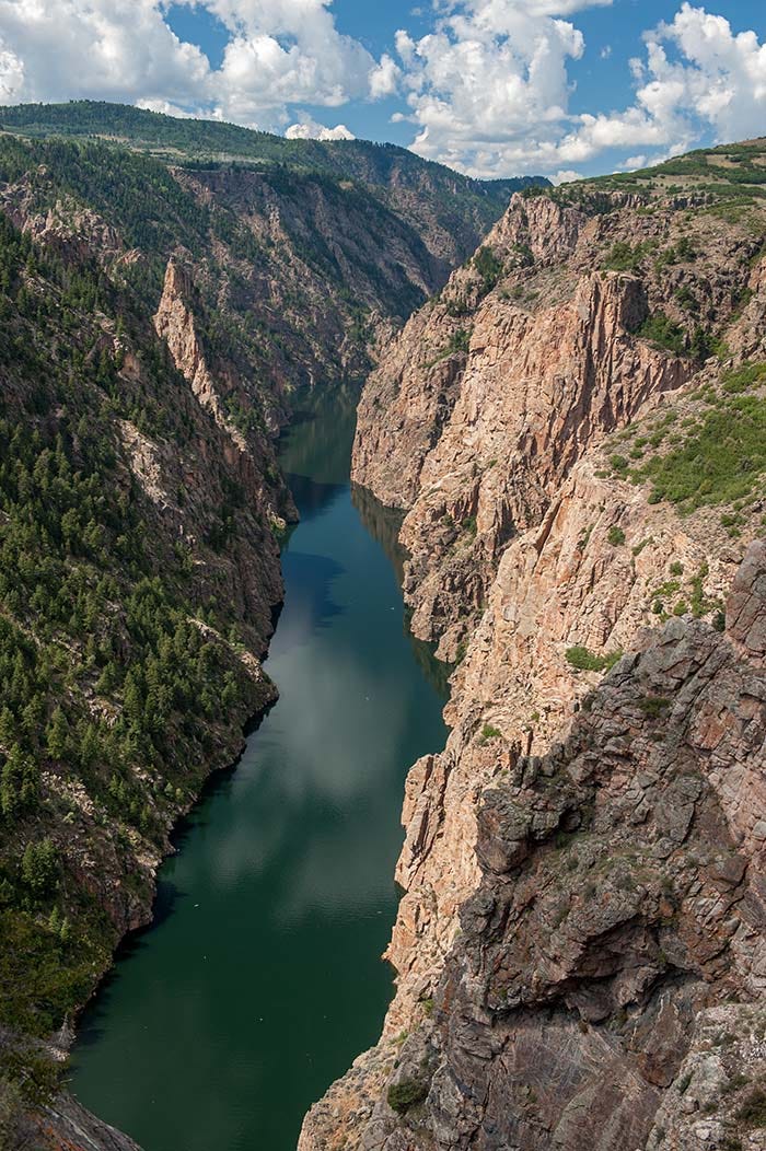
A little farther down-canyon is a viewpoint at the trailhead to Hermit’s Rest:
This photo contains several important matters of geology. This is the Morrow Point reservoir, which has flooded the Gunnison Canyon. It is easy to see that a much easier course for the river would have been through the valley beyond this ridge. So why did the river cut through all these mountains instead of taking the easier course?
The answer is that the Gunnison existed, and was flowing here, before these mountains began to uplift in the Laramide Orogeny, 70 to 40 million years ago. It had already begun cutting a channel. And as the land continued rising, the river continued cutting.
At this viewpoint, we are standing on the southern edge of the West Elk Mountains, looking south. The San Juan volcanic field, made of tuff (welded volcanic ash), is seen beginning in the near distance. The San Juans were formed about 27 to 24 million years ago.
In the distance are two of Colorado’s fourteeners, though they are too far away to point out: Uncompahgre Peak and Wetterhorn Peak, both near the left edge of the photo. Both are part of the San Juans.
The triangular bit of land down below is named Hermit’s Rest. If you look in the lower right corner of the photo, you can see a trail descending down to it. That’s almost a 2,000 foot elevation change from this viewpoint, which is at the trailhead. I don’t think I would want to hike that.
Not far from here, the road leaves the Gunnison Canyon and makes its way north to the town of Crawford, from which you can get onto a secondary road that takes you south again to the Black Canyon’s north rim. There, in my humble opinion, is the most awesome view of the Black Canyon:
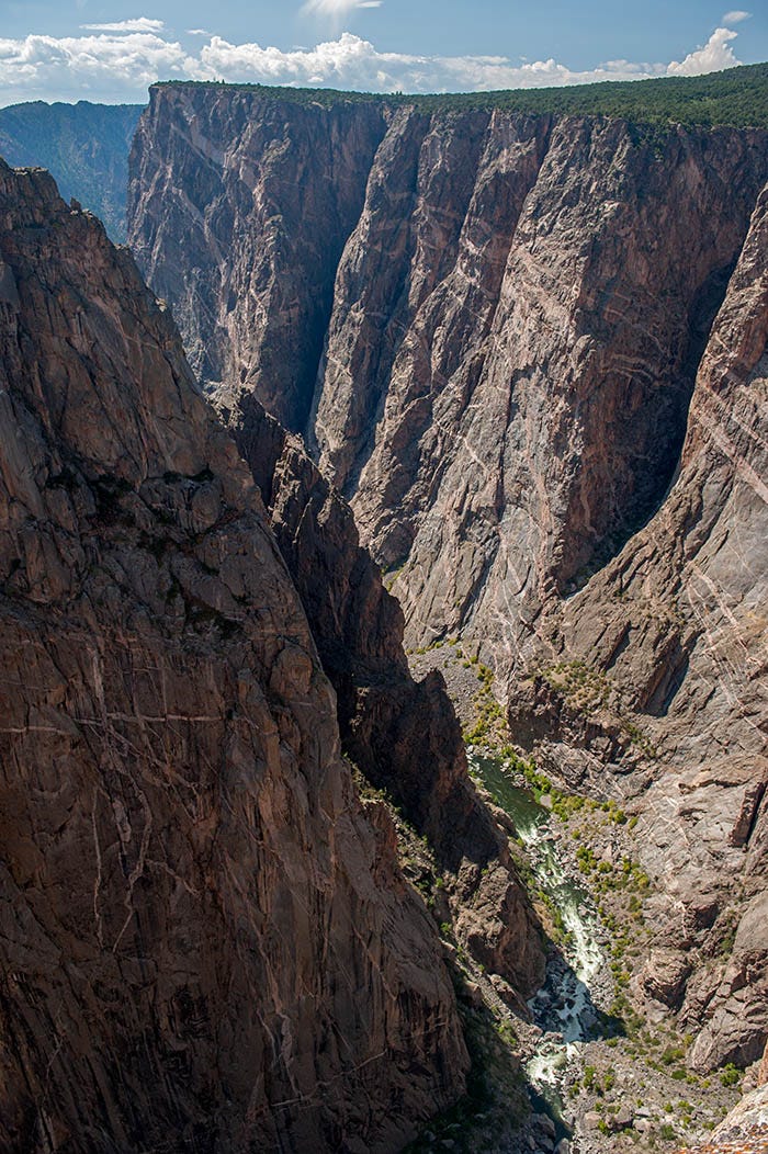
Paid subscribers have received a better version of this photo, taken a few years later from the same spot. Note, if you will, the veins of pink pegmatite in the black walls of the canyon. Geologists call this an “intrusion” and it consists of stuff that came up from below to fill cracks in the older rock. As I’ve mentioned before, the black stuff is 1.7 billion-year-old Proterozoic rock that was cooking down by Earth’s mantle until it was uplifted 70 to 40 million years ago. The pink pegmatite is 1.4 billion years old.
A few of the viewpoints along the North Rim trail have a fence or stone wall to keep you from falling; many do not. If you slip, you die. I was adjusting my polarizing filter while shooting across the canyon, when it unscrewed from my lens and fell seventeen hundred feet down to the bottom.
That unnerved me. For the rest of that day, I couldn’t shake the feeling that “YOU are next!” So I hiked back to the Jeep and headed home. My sweetheart was on a bus to Gunnison to join me for my birthday, and I had to start making the drive back anyway.
On the way out toward Crawford, I saw the strangest thing ever. It looked (to me) like the Space Shuttle! “What in the world… is THAT?” I said to myself.
I wouldn’t begin to study geology for another several years. But what it is, is a lava plug. It formed underground, after which the softer rock surrounding it eroded away.
Several years later, I moved to this area and visited that thing up close and personal. But on this particular day, I had to get back to Gunnison. My lady was waiting for me at the bus station and it’s a long, long road back to Gunnison from here.
It was my birthday. One of the best. I had seen the feared Black Canyon of the Gunnison, and didn’t fall in.
to be continued…
The largest that is fully contained within the state of Colorado
Almost every one of these terrific pictures would be worthy of a full-sized print! I would really love to see several of them in detail. Perhaps you will consider offering some of these for sale in the future?